BOUNDARIES
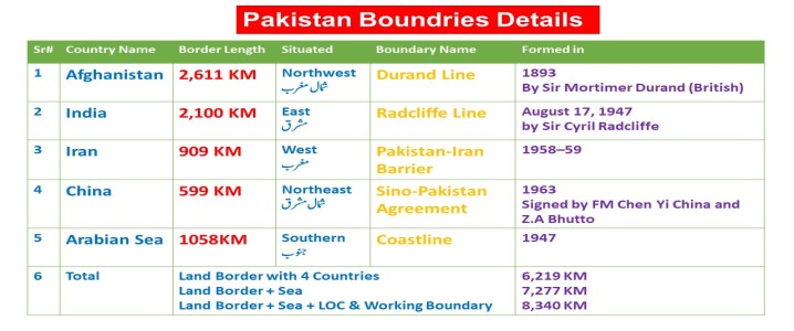
Pakistan's total land
border is 6,219 KM long
Pakistan's total land
border with four countries & Sea is 7,277 KM
Pakistan's total land
border with four countries, Sea, LOC & Working Boundary is 8,340 KM
*******
Pakistan borders India
2,100 KM long in the east,
Afghanistan border is 2,611 KM long in the west (northwest)
Iran border is 909 KM long also in the west
China's 599 KM long border is situated in the northeast.
The beach of the
Arabian Sea 1058 forms its southern border.
Source:
According to Survey of Pakistan 2020
یہ معلومات 100فیصد
درست ہیں ۔
بہت سی ویب سائیٹ اور
کتابوں میں ابھی تک معلومات غلط ہیں
سروے آف پاکستان نے
2020 میں معلومات مندرجہ ذہل بتائیں ہیں
PDF
Download
Show Answers
چار آپشن میں سے کسی ایک پر کلک کرنے سے جواب سرخ ہو جائے گا۔
مندرجہ ذیل میں سے کون سا پاکستان کے جنوب میں واقع ہے؟
Indian Ocean
China
Arabian Sea
Strait of Humoz
اس سوال کو وضاحت کے ساتھ پڑھیں
Explanation
The Arabian Sea lies in the South of Pakistan. It is located south of Pakistan with a coastline of 1,046 kilometers . Addtional information :
Pakistan is located in the North-West of India . Pakistan is located east is India , which has a 2,912 km border with Pakistan. To its west is Iran , which has a 909 km border with Pakistan. Iran and Pakistan are located in the North of the Arabian Sea. In the southern area of Pakistan, there is a mountain range called: Kirther Range Last verified on 30-03-2026
پاکستان کے ساتھ سب سے چھوٹی سرحد کس ملک کی ہے؟
Afghanistan
China
India
Iran
اس سوال کو وضاحت کے ساتھ پڑھیں
Explanation
Pakistan’s shortest international boundary is with China in the north . It lies in the Gilgit-Baltistan region along the Karakoram range. This border connects Pakistan with China’s Xinjiang province. The Khunjerab Pass is the main crossing point on this border. Additional information :
India → ~2,912 km ( Longest ) Afghanistan → ~2,430 km Iran → ~909 km China → ~523 km ( Shortest ) Last verified on 17-05-2026
پاکستان کی سب سے بڑی سرحد کس ملک کے ساتھ ہے؟
India
Afghanistan
Iran
None of these
اس سوال کو وضاحت کے ساتھ پڑھیں
Explanation
The Pakistan- Afghanistan border ( West/Northwest ) is 2,611 km long.
Additional information :
Other borders :
Arabian Sea coast: 1,058 km (South) Total land border: 6,219 km Land + Sea border: 7,277 km Land + Sea + LOC & Working Boundary: 8,340 km Last verified on 16-01-2026
پاکستان اور افغانستان کے درمیان سرحد کی لمبائی کتنی ہے؟
2611 km
2350 km
2282 km
2430 km
اس سوال کو وضاحت کے ساتھ پڑھیں
Explanation
Current/Survey of Pakistan 2021 figure: 2,611 km Older figure: 2,430 km Name of border: Durand Line Year of agreement: 1893 British representative: Sir Mortimer Durand Afghan ruler: Amir Abdur Rahman Khan Last updated 07 Nov 2026 by NA
لائن آف کنٹرول کب وجود میں آئی؟
1972
1949
1957
None of these
اس سوال کو وضاحت کے ساتھ پڑھیں
Explanation
The Line of Control (LoC) was established in 1949 after the Karachi Agreement . It was following the first Indo-Pak war over Kashmir. It was originally called the Ceasefire Line and renamed the LoC in the 1972 Simla Agreement. The LoC is approximately 740 km long . Last verified on 03-09-2026
کس معاہدے کے تحت جنگ بندی لائن کا نام تبدیل کر کے لائن آف کنٹرول رکھا گیا؟
Simla Agreement
Ceasefire Agreement
Both A and B
None of these
اس سوال کو وضاحت کے ساتھ پڑھیں
Explanation
The Line of Control (LoC) was established in 1949 after the Karachi Agreement . It was following the first Indo-Pak war over Kashmir. It was originally called the Ceasefire Line and renamed the LoC in the 1972 Simla Agreement. The LoC is approximately 740 km long . Last verified on 03-09-2026
پاکستان کو افغانستان سے متعلق عسکریت پسندی، باقاعدہ تجارت، سرحدی انتظام اور مہاجرین کی واپسی کے بیک وقت مسائل درپیش ہیں۔ ان مسائل سے نمٹنے کے لیے کون سا پالیسی فریم ورک سب سے زیادہ مربوط ہے؟
Combine secure borders, lawful trade, counter-terrorism and orderly return of refugees
Treat refugee management, trade and security as unrelated portfolios
Base policy solely on short-term political changes in Kabul
None of these
اس سوال کو وضاحت کے ساتھ پڑھیں
Explanation
Effective border management helps prevent unauthorized crossings, arms smuggling and the movement of militant groups while facilitating legitimate travel. Lawful bilateral trade supports economic activity, strengthens commercial ties and reduces incentives for informal cross-border trade. Counter-terrorism cooperation should focus on preventing militant violence , improving intelligence - sharing and protecting civilians . Last verified on 21-10-2026
پاکستان کے شمال مغرب میں کون سا ملک واقع ہ
China
India
Iran
Afghanistan
اس سوال کو وضاحت کے ساتھ پڑھیں
Explanation
Afghanistan is located to the north-west of Pakistan . Pakistan shares its longest land border (2,640 km) with Afghanistan . The border between Pakistan and Afghanistan is called the Durand Line . Additional information :
East: India North-east: China South-west: Iran South: Arabian Sea Last verified on 06-07-2026
ہندوستان پاکستان کے ____ طرف واقع ہے۔
North
West
East
South
اس سوال کو وضاحت کے ساتھ پڑھیں
Explanation
India lies to the east of Pakistan . Pakistan’s border with India is approximately 3,323 km ( 2,065 mi ) long. Additional information:
The list of Pakistan's borders:
India to the east . Iran to the west . Afghanistan to the northwest . Arabian Sea to the south . Last verified on 16-05-2026
پاکستان کی ساحلی پٹی کی لمبائی کتنی ہے؟
990 km
1125 km
1048 km
1058 km
اس سوال کو وضاحت کے ساتھ پڑھیں
Explanation
NOTE: Length: Old – 1,046 km , New – 1,058 km (both accepted in MCQs)
Divisions: Sindh Coast – 270 km , Makran Coast – 720 km Major Location: Most of the coastline is in Balochistan Geographical Areas: Gwadar, Lasbela, Karachi, Thatta Coast Borders: Thatta Coast from Korangi Creek to Sir Creek ; Rann of Kutch from Badin to Tharparkar Last verified on 15-01-2026