MOUNTAINS IN PAKISTAN MCQS
This article
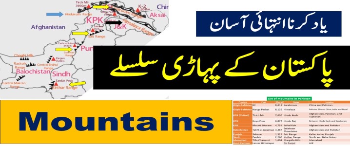
included List of mountains in Pakistan, K2, Nanga Parbat, Gasherbrum
I (K5), Broad Peak, Gasherbrum II (K4), Tirich Mir, Koyo Zom, Mount
Sikaram, Takht-e-Sulaiman, Sakesar, Zardak, Tilla Charouni peak height, length,
range, location, province, country, map, comparison, top 5 mountains in
Pakistan, 8000+ meters mountains in Pakistan.
PDF File
Important Video Lecture
Show Answers
چار آپشن میں سے کسی ایک پر کلک کرنے سے جواب سرخ ہو جائے گا۔
مشہور خیبر پاس کس پہاڑی سلسلے میں واقع ہے؟
Himalaya Range
Hindukash Range
Sulaiman Range
Safed Koh
اس سوال کو وضاحت کے ساتھ پڑھیں
Explanation
Khyber Pass lies in the Safed Koh mountain range. It is a famous mountain pass in Pakistan. It connects Pakistan with Afghanistan . It connects Peshawar to Kabul . It is a historically important trade and invasion route. It lies in the Safed Koh mountain range. Last verified on 16-05-2026
پاکستان کے جنوب میں کون سا سلسلہ ہے؟
Karakorum
Kirther
Himalayas
None of these
اس سوال کو وضاحت کے ساتھ پڑھیں
Explanation
In the southern area of Pakistan , there is a mountain range called: Kirther Range Kirthar Range , located along the Balochistan and Sindh provincial border. Elevation of Kirther mountain 2,260 m (7,410 ft). The highest peak of the Kirthar mountains is Zardak Peak at 7,430 ft (2,260 m). Last verified on 30-03-2026
کون سا پہاڑ "چہگوری یا سیویج ماؤنٹین" کے نام سے مشہور ہے؟
Mount Everest
Lhotse
K2
Kilimanjaro
اس سوال کو وضاحت کے ساتھ پڑھیں
Explanation
Nickname: Chahgori or Savage Mountain Also Known As: Godwin-Austen Height: 8,611 meters (28,251 ft) Mountain Range: Karakoram Location: Pakistan–China border "K" stands for: Karakoram Last verified on 02-07-2026
سیاچن گلیشیر کس پہاڑی سلسلے میں واقع ہے؟
Himalaya
Karakorum
Hindu Kush
Kirthar
اس سوال کو وضاحت کے ساتھ پڑھیں
Explanation
Location: Eastern Karakoram Range, Ghanche District, Gilgit - Baltistan . Length: 76 km Height: About 20,000 feet Significance: Largest glacier in Pakistan and second-largest glacier outside the polar regions . Meaning: Siachen means " Abundance of Roses " (گلاب کی کثرت). Last verified on 01-04-2026
لیڈی فنگر پیک کس ملک میں واقع ہے؟
China
Nepal
India
Pakistan
اس سوال کو وضاحت کے ساتھ پڑھیں
Explanation
Lady Finger Peak, also known as Bublimotin, is located in Pakistan It is a distinctive rock spire situated in the Batura Muztagh A sub-range of the Karakoram Range in the Gilgit-Baltistan region. First ascent: May 22, 1982, by Patrick Cordier and Jacques Maurin Last updated by NA on 16-07-2026
کون سا پہاڑی سلسلہ افغانستان کو پاکستان سے الگ کرتا ہے؟
Pamir Range
Karakorum Range
The Hindu Kush Range
None of these
اس سوال کو وضاحت کے ساتھ پڑھیں
Explanation
The Hindu Kush Range separates Afghanistan and Pakistan . It stretches across central Afghanistan into northern Pakistan. Length: Approximately 800 km ( 500 miles ) Area: About 152,800 km² Additional information :
Himalayas → Pakistan, India, Nepal, Bhutan, China Karakoram → Pakistan, China, India (Contains K2 – 8,611 m) Pamir → Tajikistan, Afghanistan, China, Kyrgyzstan ("Roof of the World") Sulaiman Range → Pakistan and Afghanistan Safed Koh (Spin Ghar) → Along the Pakistan–Afghanistan border Last verified on 15-07-2026
مندرجہ ذیل میں سے کس پہاڑی چوٹی کو قاتل پہاڑ کہا جاتا ہے؟
Nanga Parbat
Godwin Austin
Broad Peak
Raka Poshi
اس سوال کو وضاحت کے ساتھ پڑھیں
Explanation
Nanga Parbat is famously called the " Killer Mountain ." Its height 8,126 metres ( 26,660 feet ). It is located in Gilgit-Baltistan . It is part of the Western Himalayas . It is locally known as Diamer . It is the 9th-highest mountain in the world. It is famously called the " Killer Mountain ." First Ascent: 3 July 1953 Shehroze Kashif became the youngest Pakistani to successfully summit Nanga Parbat . Last verified by on 16-05-2026
سلیمان پہاڑی سلسلہ کن علاقوں کی سرحد کے ساتھ واقع ہے؟
Balochistan and Punjab/KPK
Punjab and Sindh
KPK and Afghanistan
None of these
اس سوال کو وضاحت کے ساتھ پڑھیں
Explanation
Location: Balochistan, Punjab & Khyber Pakhtunkhwa (KPK) Highest Peak: Takht-e-Sulaiman (≈ 3,487 m / 11,440 ft ) Mountain System: Part of the Sulaiman-Kirthar Mountain System Direction: Runs generally north to south Neighboring Range: Kirthar Range Last verified on 07-07-2026
بلوچستان سطح مرتفع کی اوسط اونچائی کیا ہے؟
300 to 900 meters
600 to 9000 meters
1000 to 2000 meters
None of these
اس سوال کو وضاحت کے ساتھ پڑھیں
Explanation
The average height of the Balochistan Plateau is about 600 to 900 meters above sea level Therefore, the correct option from your list is 300 to 900 meters. It is the largest plateau in Pakistan. The region is mostly dry, mountainous, and arid . Last verified on 23-06-2026
کوهِ سفید متن کے مطابق کن دو دریاؤں کے درمیان واقع ہے؟
Ravi and Sutlej
Indus and Jhelum
Kabul and Kurram
None of these
اس سوال کو وضاحت کے ساتھ پڑھیں
Explanation
Koh-e-Sufaid is a mountain range in the north-west of Pakistan and Afghanistan . It is also known as Spin Ghar . It is located between the Kabul River and Kurram River region. It is part of the Hindu Kush mountain system. Last verified on 24-05-2026