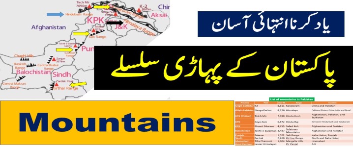
MOUNTAINS IN PAKISTAN MCQS
This article
included List of mountains in Pakistan, K2, Nanga Parbat, Gasherbrum
I (K5), Broad Peak, Gasherbrum II (K4), Tirich Mir, Koyo Zom, Mount
Sikaram, Takht-e-Sulaiman, Sakesar, Zardak, Tilla Charouni peak height, length,
range, location, province, country, map, comparison, top 5 mountains in
Pakistan, 8000+ meters mountains in Pakistan.
PDF File
Important Video Lecture
Show Answers
چار آپشن میں سے کسی ایک پر کلک کرنے سے جواب سرخ ہو جائے گا۔
باران ندی کس صوبے میں بہتی ہے؟
KPK
Sindh
Balochistan
Punjab
اس سوال کو وضاحت کے ساتھ پڑھیں
Explanation
The Baran river, also known as the Nai Baran river or Baran Nai,
It is situated in the Sindh province of Pakistan
A hill torrent that ranges from the Sindh to the Balochistan provinces of Pakistan , at the foot of the Kirthar Mountains range.
راکاپوشی کا دوسرا نام دمانی ہے، جس کا مطلب ہے؟
Mother of Mist
Land of Giants
Cold Peak
Frozen Valley
اس سوال کو وضاحت کے ساتھ پڑھیں
Explanation
Rakaposhi is also known as Dumani , meaning "Mother of Mist" or "Mother of Clouds."
Additional information
Rakaposhi is the 27th-highest mountain in the world.
It is the steepest peak in the world.
It is located in the Gilgit-Baltistan region of Pakistan.
Rakaposhi rises over the Nagar Valley.
It is the part of the Karakoram range .
It is the 12th highest mountain in Pakistan.
The first successful ascent was in 1958 by Mike Banks and Tom Patey.
زردک کس پہاڑی سلسلے کی سب سے اونچی چوٹی ہے؟
Karakoram range
Sulaiman range
Kirthar range
Hindukush range
اس سوال کو وضاحت کے ساتھ پڑھیں
Explanation
Zardak Peak is the highest peak of the Kirthar Mountains
It is the most prominent mountain in Balochistan
It is 7,438 feet (2,267 m) high.
It is bordered by
The east by the Indus plains
The west of the Iranian plateau.
مکلی پہاڑی قبرستان کس شہر میں واقع ہے؟
Karachi
Hyderabad
Makli
Thatta
اس سوال کو وضاحت کے ساتھ پڑھیں
Explanation
Makli Necropolis was inscribed as a UNESCO World Heritage Site in 1981.
Makli Necropolis , located in Thatta , Pakistan.
It is one of the largest funerary sites in the world.
It is the final resting place of some 125,000 local rulers, Sufi saints, and other eminent persons from the 14th to the 18th century.
نانگا پربت کا دوسرا نام کیا ہے؟
Kirther
K-2
Safed koh
Diamir
اس سوال کو وضاحت کے ساتھ پڑھیں
Explanation
Nanga Parbat, known locally as Diamer
Diamir is a local name for the peak and means “king of the mountains.”
The height of Nanga Parbat at 8,126 m (26,660 ft) above sea level.
Worldwide Nanga Parbat is the 9th highest mountain.
The meaning of Nanga Parbat is Naked Mountain
It is also called Killer Mountain Peak.
In 1954, the mountain peak of Nanda Parbat was conquered
First ascent July 3, 1953
Location Gilgit–Baltistan, Pakistan
Mountain range is Nanga Parbat is Himalayas, Western Himalaya
داسپنگ کس پہاڑ کا دوسرا نام ہے؟
K-2
Nanga parbat
Rakaposhi
Mount Everest
اس سوال کو وضاحت کے ساتھ پڑھیں
Explanation
Dapsang is another name for K2
Dapsang is the name used by locals in the Balti language.
K2 was given the initial "K" designation because it was the second mountain surveyed in the Karakoram Range
K2: The original survey name
Chogori: Another local name for K2, which means "king of mountains".
Mount Godwin Austen: Named after Henry Godwin-Austen, an English geographer who surveyed the mountain.
پاکستان کے شمالی علاقوں میں کونسا پہاڑی سلسلہ واقع ہے؟
Hindu Kush
Kirthar
Karakoram
Hamaliya
اس سوال کو وضاحت کے ساتھ پڑھیں
Explanation
Northern Pakistan is dominated by three major mountain ranges:
The Karakoram The Himalayas The Hindu Kush. These ranges converge in this region, which is home to many of the world's highest peaks, including K2.
Karakoram:
Located in the northernmost parts of Pakistan, it contains the second-highest peak in the world, K2.
Himalayas:
This range runs along the western side of Pakistan and includes the peak Nanga Parbat, the highest in the country.
Hindu Kush:
Situated in the northwest of Pakistan, this range extends into Afghanistan and has the pea k Tirich Mir as its highest point in the region.
پوٹھوہار سطح مرتفع معدنی ذخائر پر مشتمل ہے؟
Rock Salt
Gypsum
Oil
All of these
اس سوال کو وضاحت کے ساتھ پڑھیں
Explanation
The Pothohar Plateau also known as Pothwar , is a plateau in north-eastern Pakistan
the total area of about 5000 miles2
located between the Indus River and the Jhelum River
300-600 meters is the height of the Pothohar Plateau
******
The Potwar Plateau includes parts of the current four districts :
Jhelum
Chakwal
Rawalpindi
Attock
****
The Pothohar plateau is rich in minerals like gypsum , limestone , coal, oil, and rock salt.
Potohar Plateau سطح مرتفع پوٹھوہار of:
District Rawalpindi District
Islamabad Capital Territory
Chakwal District
Jhelum District
Khushab District,
Mirpur District
Islamabad
Mianwali District,
Sargodha District (Northern Belt)
سال 2023 مندرجہ ذیل میں سے کون سا پاکستانی خاتون ماؤنٹ ایورسٹ پر چڑھ گئی ہے؟
Naila Kiani
Nida Dar
Mehwish Hayat
None of these
اس سوال کو وضاحت کے ساتھ پڑھیں
Explanation
On 14 May 2023 , Naila Kiani becomes second Pakistani woman to scale Mount Everest
All about Mount Everest
Mount Everest is the Highest peak in the world .
The highest part of the Earth is Mount Everest
It is located in Nepal.
The new height of Mount Everest is 8,848.86m (29,032 feet).
Mount Everest was named after George Everest in 1856
First time Mount Everest expedition in 1953
Mount Everest is present in the range of mountains: the Himalayas
*****
the first person to reach Mount Everest:
Sherpa Tenzing and Edmund Percival Hillary
****
The first man to climb Mount Everest twice was:
Nawang Gombu
***
The first Pakistani woman to scale Mount Everest is:
Samina Baig
***
the first blind man in Asia and the third in the world to climb Mount Everest:
Zhang Hong
****
the youngest Pakistani to summit Mount Everest (8,848m), the tallest peak in the world:
Sheroze Kashif
****
Who has made a world record and become the fastest in the women's category to Scale Mount Everest?
Tsang Yin-hung
تخت سلیمان کی چوٹی کس صوبے میں واقع ہے؟
Sindh
Punjab
Khyber Pakhtunkhwa
Balochistan
اس سوال کو وضاحت کے ساتھ پڑھیں
Explanation
Takhat-e-Sulaiman peak Elevation 3,487 m. George White.
Takhat-e-Sulaiman peak is located in Balochsitan .
The Takht-e-Sulaiman peak is located on the border of both the Khyber Pakhtunkhwa and Balochistan provinces in Pakistan. The peak is situated in the Sulaiman Mountains , near the town of Darazinda and the borders with both South Waziristan and Zhob.