BOUNDARIES
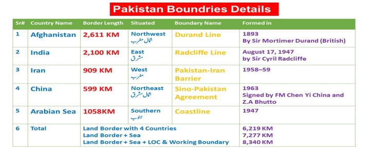
Pakistan's total land
border is 6,219 KM long
Pakistan's total land
border with four countries & Sea is 7,277 KM
Pakistan's total land
border with four countries, Sea, LOC & Working Boundary is 8,340 KM
*******
Pakistan borders India
2,100 KM long in the east,
Afghanistan border is 2,611 KM long in the west (northwest)
Iran border is 909 KM long also in the west
China's 599 KM long border is situated in the northeast.
The beach of the
Arabian Sea 1058 forms its southern border.
Source:
According to Survey of Pakistan 2020
یہ معلومات 100فیصد
درست ہیں ۔
بہت سی ویب سائیٹ اور
کتابوں میں ابھی تک معلومات غلط ہیں
سروے آف پاکستان نے
2020 میں معلومات مندرجہ ذہل بتائیں ہیں
PDF
Download
چار آپشن میں سے کسی ایک پر کلک کرنے سے جواب سرخ ہو جائے گا۔
سر کریک کس کے درمیان واقع ہے؟
- India & China
- Pakistan & India
- Pakistan & Afghanistan
- Pakistan & Iran
اس سوال کو وضاحت کے ساتھ پڑھیں
Explanation
- Sir Creek is located between Pakistan & India
- ***
- Sir Creek is located along the southeastern border of the Sindh province of Pakistan and the western border of the Gujarat province in India.
- This area is called the Greater Rann of Kutch, a marshland situated along the Arabian Sea.
- ***
- Sir Creek is important to Pakistan because: It is environmentally important to prevent coastal wetlands from degradation
- About 90 km2 of the lake comes under Pakistan, whilst the majority of the lake i.e. 210 km2, lies within India.
علاقے کی ایک تنگ پٹی ہے جو پاکستان، افغانستان، چین اور تاجکستان کو الگ کرتی ہے۔ ______
- Khunjerab
- Ladakh
- Wakhan
- Hunza
- Khojak
اس سوال کو وضاحت کے ساتھ پڑھیں
Explanation
The Wakhan Corridor is a field in the northeastern part of Afghanistan that extends into China and separates Tajikistan and Pakistan.

سندھ کے متنازعہ علاقے سر کریک پر پاکستان اور بھارت کے درمیان سرحدی لائن کا علاقہکیا کہلاتا ہے
- Green Line
- Blue Line
- Red Line
- Yellow Line
اس سوال کو وضاحت کے ساتھ پڑھیں
Explanation
Indo-Pakistani Border Dispute. The Green Line is the boundary as claimed by Pakistan, the Red Line is the boundary as claimed by India.
Additional information:
- Sir Creek is located between Pakistan & India
- It is located along the southeastern border of the Sindh province of Pakistan and the western border of the Gujarat province in India.
- This area is called the Greater Rann of Kutch, a marshland situated along the Arabian Sea.
- ***
- Sir Creek is important to Pakistan because: It is environmentally important to prevent coastal wetlands from degradation
- About 90 km2 of the lake comes under Pakistan, whilst the majority of the lake i.e. 210 km2, lies within India.
بھارت اور چین کی سرحد کو کیا کہا جاتا ہے؟
- McMahon Line
- 17th Parallel line
- Curzon Une
- Green Line
اس سوال کو وضاحت کے ساتھ پڑھیں
Explanation
The boundary line between India and China is called the McMohan Line
This line was negotiated between Tibet and Great Britainat the End of the Shimla Conference
The line was drawn between Oct 1913 and July 1914
It was named after Sir Henry McMahon
Boundaries
| Between
|
| MacMahon line | China and India |
| Durand Line | Pakistan and Afghanistan |
| Radcliffe Line | India and Pakistan |
| 24th Parallel | India and Pakistan |
| Maginot Line | Germany and France |
| Mannerheim Line | Russia and Finland |
| Oder-Neisse Line | Poland and Germany |
شمالی مغربی حصے پر، خیبر پختونخوا کی ____ کے ساتھ مشترکہ سرحد ہے؟
- Afghanistan
- China
- Iran
- India
اس سوال کو وضاحت کے ساتھ پڑھیں
Explanation
Khyber Pakhtunkhwa, a province in Pakistan, shares its northwestern border with Afghanistan, separated by the Durand Line.
It is bounded by:
- Afghanistan to the west and north.
- Azad Kashmir and Gilgit-Baltistan to the east and northeast.
- Punjab province to the southeast.
- Balochistan province to the southwest.
پنجاب باؤنڈری کمیشن میں پاکستان کی نمائندگی کس نے کی؟
- S.A. Rehman and Abu Saleh Muhammad Akram
- Nawab Abdur Rab Nishtar and Ch. Rehmat Ali
- Khawaja Nizamuddin and Zafar Ali Khan
- Din Muhammad and Muhammad Munir
اس سوال کو وضاحت کے ساتھ پڑھیں
Explanation
Nawab Abdur Rab Nishtar and Choudhry Rehmat Ali represented Pakistan on the Punjab Boundary Commission.
They played a crucial role in the partition process, helping to determine the boundaries of the newly created Pakistan.
ہندوستان اور پاکستان کے درمیان "کچھ کے رن کا معاہدہ" کس سال ہوا؟
- 1965
- 1967
- 1966
- 1968
اس سوال کو وضاحت کے ساتھ پڑھیں
Explanation
- The Indo-Pakistani War of 1965 involved skirmishes between April and September 1965.
- Pakistan claims the 24th Parallel as the boundary in the Rann of Kutch, but India does not recognize it.
- The "Treaty of Rann of Kutch" was signed on 30 June 1965, resolving the territorial dispute.
- ASEAN
- CENTO
- SEATO
- NATO
اس سوال کو وضاحت کے ساتھ پڑھیں
Explanation
SEATO is the Name of the pact joined by Pakistan and the United Kingdom In 1954 and dissolved on 30th June 1977
*****
On 8th September 1954, the Southeast Asia Treaty Organization, or SEATO formed by :
- the United States,
- France,
- Great Britain,
- New Zealand,
- Australia,
- the Philippines,
- Thailand,
- and Pakistan
****************
while the Central Treaty Organization (CENTO) was formed in 1955 by nd dissolved in 1979.
:
- Iran,
- Iraq,
- Pakistan,
- Turkey,
- and the United Kingdom
****************
ND05-12-2022
چین کی سرحد سے پہلے پاکستان میں شاہراہ قراقرم پر آخری قصبہ کونسا ہے؟
- Sost
- Astore
- Bunji
- None of these
اس سوال کو وضاحت کے ساتھ پڑھیں
Explanation
Sust is a village in Hunza.
It's the last town in Pakistan on the Karakoram highway before the Chinese border.
پاکستان اور افغانستان کی سرحد کی لمبائی کتنی ہے
- 430 KM
- 1430 KM
- 2430 KM
- 2611 KM
اس سوال کو وضاحت کے ساتھ پڑھیں
Explanation
According to the Survey of Pakistan 2021, the new length border between Pakistan and Afghanistan is 2611 km
The old length between Pak vs Afghanistan is 2430
Pakistan and Afghanistan are called the Durand Line
The Durand line was drawn in 1893
Durand line agreement between Mortimer Durand and Abdul Rahman.
Additional information:
Pakistan's total land border is 6219KM long
Pakistan's total land border with Land Border + Sea 7277KM
Land Border + Sea + LOC & Working Boundary 8340 KM
Pakistan borders India 2100 KM long in the east
Afghanistan border is 2,611 KM long in the west (northwest)
Iran border is 909 KM long also in the west
China's long border is situated in the northeast.
The beach of the Arabian Sea 1058 km forms its southern border.


