BOUNDARIES
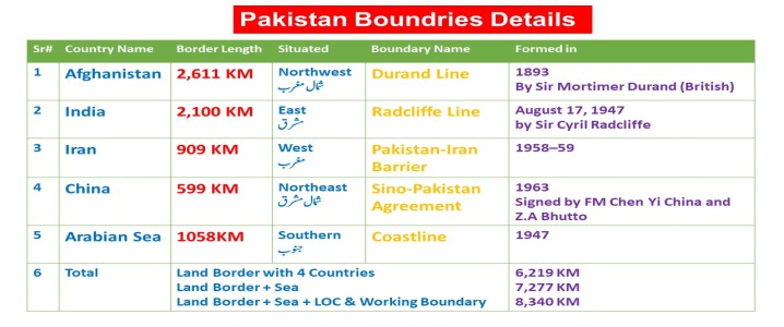
Pakistan's total land
border is 6,219 KM long
Pakistan's total land
border with four countries & Sea is 7,277 KM
Pakistan's total land
border with four countries, Sea, LOC & Working Boundary is 8,340 KM
*******
Pakistan borders India
2,100 KM long in the east,
Afghanistan border is 2,611 KM long in the west (northwest)
Iran border is 909 KM long also in the west
China's 599 KM long border is situated in the northeast.
The beach of the
Arabian Sea 1058 forms its southern border.
Source:
According to Survey of Pakistan 2020
یہ معلومات 100فیصد
درست ہیں ۔
بہت سی ویب سائیٹ اور
کتابوں میں ابھی تک معلومات غلط ہیں
سروے آف پاکستان نے
2020 میں معلومات مندرجہ ذہل بتائیں ہیں
PDF
Download
Show Answers
چار آپشن میں سے کسی ایک پر کلک کرنے سے جواب سرخ ہو جائے گا۔
پاکستان اور چین کو سال 1963 میں ایک معاہدے کی وجہ سے پاکستان کے شمال میں زمین کے ساتھ جوڑا گیا ہے ، جس کا نام لیا گیا تھا؟
Pakistan Free Trade Agreement
Sino-Pak Agreement
Pak-China Border Agreement
None of these
اس سوال کو وضاحت کے ساتھ پڑھیں
Explanation
Negotiations between the nations officially began on October 13, 1962, and resulted in an agreement being signed on 2 March 1963 .
It was signed by foreign ministers Chen Yi for the Chinese and Zulfikar Ali Bhutto for the Pakistani.
The eastern tip of the Wakhan Corridor starts the Sino-Pak border between the People's Republic of China and Pakistan spanning about 559 km (347.3 mi).
Zulfikar Ali Bhutto, the Minister of External Affairs of Pakistan.
دو جولائی ، 1972 کو ، سملا معاہدہ سیز فائر لائن کے طور پر کنٹرول لائن پر ______ کے ذریعہ دستخط ہوئے؟
Zulifqar Ali Bhutto
General Yahya Khan
General Ayub Khan
None of these
اس سوال کو وضاحت کے ساتھ پڑھیں
Explanation
The Simla Agreement was signed on July 2, 1972 between Zulifqar Ali Bhutto (Pakistan) and Indira Gandhi (India).
It converted the ceasefire line in Kashmir into the Line of Control (LoC).
واکھن کوریڈور ، افغانستان کی ایک تنگ پٹی پاکستان کو کس ملک سے الگ کرتی ہے؟
Afghanistan
Tajikistan
China
India
اس سوال کو وضاحت کے ساتھ پڑھیں
Explanation
The Wakhan Corridor is a narrow strip of territory in Afghanistan, extending to China and separating Tajikistan from Pakistan and Kashmir.
The corridor was formed in 1893 and created the Durand Line.
The Wakhan Corridor is about 350 km long .
کس ملک کی سرحدوں کے ساتھ قراقورم رینج مغرب سے مشرق تک کشمیر اور گلگٹ میں پھیلا ہوا ہے؟
China
Afghanistan
Iran
None of these
اس سوال کو وضاحت کے ساتھ پڑھیں
Explanation
The Karakoram Highway (KKH) is also known as the Friendship Highway in China and N-35 in Pakistan. It was built by the governments of Pakistan and China and completed in 1979. Starting from Hassan Abdal , it spans 1,300 (810 miles) km in Pakistan. The Silk Route is also referred to as the Karakoram Highway. The Karakoram Range , located between China and Pakistan. It is traversed by the Karakoram Highway . It connects the two countries via the Khunjerab Pass .
افغانستان کی پٹی تاجکستان کو پاکستان سے کہاں الگ کرتی ہے؟
Durand line
Wakhan
Control line
None of these
اس سوال کو وضاحت کے ساتھ پڑھیں
Explanation
The Wakhan Corridor is a narrow strip of territory in northeastern Afghanistan that extends to China .
It separates Tajikistan from Pakistan .
It is lies between Pakistan’s Gilgit-Baltistan region and China’s Xinjiang province.
1600 kilometers
1200 kilometers
1800 kilometers
None of these
اس سوال کو وضاحت کے ساتھ پڑھیں
Explanation
پاکستان کی لمبائی تقریباً 1600 کلومیٹر ہے۔
یہ لمبائی ملک کی شمالی سرحد سے جنوبی سرحد تک پھیلی ہوئی ہے۔
گنڈا سنگھ والا بارڈر کس سے منسلک تھا؟
Kasur and Ferozpur
Lahore and Amritsar
Sialkot and Ferozpur
None of these
اس سوال کو وضاحت کے ساتھ پڑھیں
Explanation
The Pakistani village of Ganda Singh Wala served as the main border crossing between India and Pakistan in the 1960s & 70s.
It was closed to trade & transit in 1986 and the main border crossing was shifted north to Wagah.
******
RY 15-01-2023
سن 1947 میں برصغیر کی تقسیم کے وقت باؤنڈری کمیشن کا چیئرمین کون تھا؟
Lord Wavell
Lord Mountbatten
Lord Radcliffe
None of these
اس سوال کو وضاحت کے ساتھ پڑھیں
Explanation
Cyril Radcliffe was the chairman of the Border Commission for India and Pakistan , announced by Lord Mountbatten in 1947
The Commission consisted of four members from the Indian National Congress
and four from the Muslim League
On 17 August 1947, the borderline that separated India from Pakistan, known as the Radcliffe Line was revealed.
The Radcliffe line is spread through the Rann of Kutch in Gujarat to the international border in Jammu in Jammu & Kashmir,
dividing India and Pakistan into two different countries.
ND23-4-2023
سن 1965 میں ، پاکستان اور ہندوستان کے مابین رن کوچ کے معاملے کو ______ کی کوششوں سے حل کیا گیا؟
Britain
America
Saudi Arabia
None of these
اس سوال کو وضاحت کے ساتھ پڑھیں
Explanation
The Indo-Pakistani War of 1965 involved skirmishes between April and September 1965.
Pakistan claimed the 24th Parallel as the boundary in the Rann of Kutch but India does not recognize it.
The " Agreement of Rann of Kutch " was signed on 30 June 1965 .
It resolving the territorial dispute through British mediation.
پاکستان نے ایران کے ساتھ سرحدی معاہدے پر دستخط کب کیے؟
1947
1958
1967
1977
اس سوال کو وضاحت کے ساتھ پڑھیں
Explanation
In 1958 , Iran and Pakistan signed an agreement in Tehran to clarify their border
History
They were both members of the Central Treaty Organization (CENTO) during the Cold War.
Iran helped Pakistan in the 1965 and 1971 Indo-Pakistani Wars.
In 2004, Pakistan and Iran signed a Preferential Trade Agreement (PTA).
The agreement became operational in 2006 .